| Date: | | 9th. March 2007 |
| County: | | CORNWALL |
| Location: | | Chapel Porth, St. Agnes |
| Type: | | Scenic Area (Coast), Historical Ruins |
| Sub-Type: | | Coast, Headland, Mines |
| Viewed by: | | WALK from car park |
| Car Park: | | Free in winter. NT day charge in summer |
| Difficulty: | | Moderate. Some climbing. Can get muddy. |
| Distance: | | xKm |
| Season: | | Winter |
| Weather: | | Sunny with light cloud. |
| Time Of Day: | | Mid to Late Afternoon |
| Camera: | | Casio Exilim EX-Z850 Pocket Zoom (JPG) |
| Scene Rating: | | ••••• |
Please note: all data and opinions presented on this site are offered in good faith, but they are advisory only and are utilised at the risk of the user. The authors can accept no blame or liability for any loss or accident or other negative effect resulting from errors, omissions or data that has changed over time.
Original photographs found on this website are Copyright © Richard Baskerville 2015, All Rights Reserved. If small versions of other photographs are found here, they act only as links to larger versions on their originating websites. Such images may be copyrighted by their original owners. Please see the linked websites for copyright details.
Chapel Porth to St Agnes: Summary
Under construction.
Under construction

 Salisbury Cathedral from the North-East (mid-morning)
From the absence of posts during February you might think that the weather was too bad to do any walking. In fact, despite having a variety of other committments, we did manage to take a few short walks, but none of them were long enough to make a complete "story."
This walk was actually made on the 9th. March 2007, but many photos (above Trevaunance Cove) were drawn from a February walk - so I'm posting it before our trip to St. Piran's oratory.
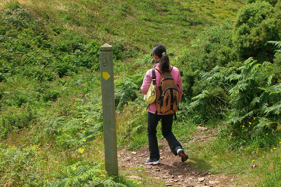
Since we had only 2 hours free, we asked to be driven to the top of the valley leading to Chapel Porth, so that we could start off by following the little stream down to the edge of the beach.

Chapel Porth is a small cove 3 miles from St. Agnes and about the same distance from Porthtowan, to the south-west.It is uninhabited. The only building is a kiosk in the beach car-park, which sells hot food, drinks and ice-creams - including a speciality called a "hedgehog." This consists of Cornish ice-cream and a topping of crushed hazel-nuts - giving it the rough brown appearance from which it derives its name.I had one with my mother on a visit prior to her death in 1998, so it's gained a kind of sentimental attachment. But alas, the kiosk wasn't open and we couldn't reprise the experience.

From the car-park, the gravelly path strikes up the hill and quickly rises to a low crest.From there it splits: one branch following a shallow valley inland, the other dropping slightly and then rising up to the coastal headland.

Although the weather was sunny, the wind was so strong that it was hard to hold the little Casio camera steady in the gusty blasts.Initially I tried to hold the framing until the wind dropped for a moment and I could take the shot - but this often meant that Xue was 200-300 metres ahead of me by the time I pressed the button. So later I just set the shutter at 1/1000th. second, shot four times more than normal and hoped for the best!Walking up the path, in the lee of slopes or rocky outcrops, the wind was already blustery. But we only felt the full force when we reached the unsheltered headland. The wind was so unrelenting that it quite literally took your breathe away.We considered that it was probably a good thing we hadn't managed to buy hedgehogs, otherwise we'd have probably come back wearing more ice-cream than we'd managed to eat!

Just before you reach the headland (where the view to the south-west is initially blocked by a small rocky crag) you can look down on to Chapel Porth beach.The tide was approaching its highest point, so the beach was quite small and entirely surrounded by the cliffs. When the tide is "out" a mile-long strip of sand links the Chapel Porth beach to the beach at Porthtowan - although walkers taking this route need to be careful not to be "caught by the tide" and trapped against the cliffs as the tide sweeps back.If you're very lucky you can sometimes see dolphins swimming just beyond the line of surf beyond this beach (as I did while walking with my parents in the early 1990s.)

Not long after the path from Chapel Porth joins the headland, you can see the Towan Roath engine house, perched dramatically on the side of a steep slope descending towards the sea.Towan Roath is the most iconic building in the area and many St. Agnes postcards stores feature the building, from many different angles and at different times of day.

Quite often the postcards just gloss the picture of Towan Roath as "Wheal Coates," but this is only half true. The whole mine was called "Wheal Coates," (now also the name of a ward in Treliske Hospital.) Most of the derelict buildings from the mine are actually on the hill high above Towan Roath and are nowhere near as picturesque.In other words, Towan Roath engine house was a
part of Wheal Coates, but by no means all of it. The mine actually had three engine houses, for winding pumping and crushing the ore into a size small enough to be sold or processed.So far, I have not managed to find the reason for situating Towan Roath so far from the other mine buildings.

Wheal Coates came into operation in 1802 and worked intermittently until 1889. It was then revived again just prior to the First World War, between 1911 and 1913.It is said that the mine-shaft descends beneath the headland to lower than sea-level, and that it can also be accessed from a cave at the botom of the cliffs. We did not try to verify this!
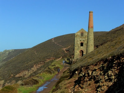
The Wheal Coates buildings are today owned by the National Trust.As with other mine buildings in the area, repairs have been made to make the stone and brick chimneys and walls stable, so that they pose no danger to the public from falling masonary.Close to the ruin you become unaware of the unusual and lonely location, overlooking the sea, but the rising walls and chimney of the engine house still stand as a majestic bulwark against the blue sky.

The closer I got to the building, the harder it was to hold the camera still enough to avoid it being shaken by the insistent blast of the wind.There was no shelter at all to resist the wind's aggression, as it rushed up the slope from the tops of the cliffs. The conditions for miners manning the building during the winter gales that often hit the Cornish coast can only be imagined.

From the coastal path which runs past Towan Roath, you can see the wide sweep of the North Cornish coast, up to to St. Ives.I generally avoided trying to shoot in that direction since the sun was facing into the lens, causing the photographs to flare and streak.But given the strong silhouette of Towan Roath I did attempt one contra-jour shot and the result was quite acceptible - although digital cameras seem not to hold backlit subjects as well as film.

The coastline itself seemed to be rather less scenic here than closer to St. Agnes - or between St. Agnes and Perranporth. Tubby's Head looked interesting on the map, but was not very dramatic when we walked above it.The rocks at the tip of St. Agnes Head (actually about a mile from St. Agnes itself) were rather more attractive.There were quite dense belts of heather here, but the fibrous fingers of the roots had not had enough grip to prevent some the soil and shale from sliding down towards the waves.
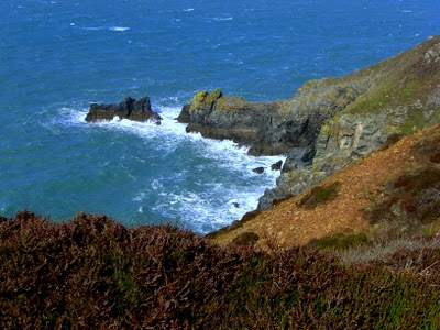
Perched on top of the hill above St. Agnes Head is a small coast guard station, which was taking the full brunt of the wind.There were some protruding rocks on the headland here, which gave some welcome shelter from the buffetting, so sat in the lee with our backs against the stone bluff for some while, enjoying the view and regaining our breath.The small rock "island" and the even smaller rock by its side (out to sea in the background) are well-known St. Agnes landmarks that seem to be called by no less than three names: the Bawden Rocks, The Man and His Man and The Cow and Calf. Take your pick!

The coast guard station is a small, white-painted wooden hut.I have been past it many times and have never seen any semblance of activity there - so I've no idea what it's actually used for.But here it is, anyway, for the record...

From St. Agnes Head the path heads east-north-east to pass over the neck of Newdowns Head.The land is still sloping gently to the sea where the path crosses it, which makes it difficult to get a good photograph from this direction.There is still no shelter here and the tough vegetation still hugs the surface to avoid the prevailing wind. At the top is a silver National Trust sign which tells you that you are passing Newdowns Head (because you probably won't have noticed) ...

This is the close-up of the sign (taken less for documentary reasons, than for the fact that I was attracted by the contrast between the silver of the sign and the stone and plants which make up the corner of one of the many dry-stone walls which separate the farmers' fields from the National Trust property along the coastal path.)

You can get a distant view of Newdowns Head by shooting obliquely back across the path.The rectangular dot on the horizon is the coast guard station on the high point above St. Agnes Head, that we'd passed 15 minutes before.

From this point onwards we were back to familiar views - that's Trevellas in the background and the start of the coastal road towards Perranporth (which is described in the next post.)We'd found no real shelter from the wind since the rocks near St. Agnes Head, so we just kept moving. The wind was starting to make us cold.It was not until we drew level with Polberro Cove that we started to get some thorns and other shrubbery on the seaward side...

...which were tall enough to act as a windbreak and reduce the strength of the wind.The path from Chapel Porth had been dry up until now, but the protection of the bushes was enough to reduce the wind's evapourative power and keep a boggy patch in their lee.The name "Polberro" is also shared by a mine about half way between Polberro Cove and Wheal Friendly (see earlier post.) The Polberro mine was the last operational mine in St. Agnes. It closed in 1941.

There were still no buds on the smooth-barked trees, although the strong presence of a silver-green growth made the small tree look like a curious kind of ever-green.The silvery colour contrasted strongly with the dead ruddy-brown fern-bracken that ran alongnside the path beyond the trees, as if they were emulating metal tones to fit in with the areas mining history. The copper colour of the dry bracken was common in the area and was the dominant colour on the slope of the hill which formed the other side of the valley, towards the Wheal Kitty mine.

It was hard to tell whether the "silver-green growth" was a parasite or a lichen.

Even a close look gave no real clues.But the tree seemed not to be suffering any ill effect, so it was less likely to be a parasite than something, like a lichen, which could generate its own nutrition, rather than just stealing it.

From that point onward we were following a path we'd taken many times before, so I stopped taking photographs and we quickly made our way back home to escape from the wind.I had, in any case, shot the views along this route on another sunny day a few weeks earlier. On that day the breeze had been calmer and the tide had been out, revealing the mass of rocks between Trevaunance Cove and TrevellasThe rocks are a good habitat for shellfish and you can sometimes find large crabs wedged in narrow crevasses in rocks close to the low-water line.

As you drop down the slope of the headland you reach the top of the cliffs on the south-western side of Trevaunance Cove.

There are some houses here, built along a narrow ledge of land between the slope up to the the headland and the cliffs down to the beach.From above the path the houses and gardens seem solid enough, but when viewed from the bay they look as if they are perched on the lip of doom!

The pay-off for those living there is the wide and unrestricted view of Trevaunance beach.In the winter, there are few people walking there and they become insignificant dots on the expanse of sand - giving an aura of either solitude or loneliness, depending on your mood.

The prettiest house is covered from top to bottom by encroaching ivy, so that it's hard to see where the garden ends and the walls begin!

Viewed from further down the road, it's also hard to see where the garden ends and the cliffs begin - since the garden just seems to topple over the top!I mentioned in a previous post that Trevaunance had once contained a harbour, but that it had been destroyed by a winter storm. The remains of the stones which were once in the harbour walls can be seen here - at the bottom of the cliffs.

From the entrance to the Trevaunance beach, the road gentle rises to the outskirts of St. Agnes itself and joins the Perranporth road - and roads to many other parts of St. Agnes - at Peterville.The road from the beach can be seen here, just above the white car. The road rising to the left is Town Hill, at the top of which is the entrance to the Stippy-Stappy terrace and the small Anglican Church which gives its name to that area: "Churchtown."To the left of Town Hill, another road (British Road) goes up to the Miners' And Mechanics' Institute in the centre of St. Agnes, while the road from which the blue car is driving leads to another two roads: to Water Lane and the upper part of St. Agnes respectively. Opposite that junction is a steep road up to Wheal Kitty - so you can see that Peterville is actually a small knot of houses around a small web of road junctions!Despite this, you can find two pubs, two surf shops, a convenience store, a boutique and a few other shops here - along with a new Chinese restaurant (the "China Palace") which is due to open in May 2007.

The road leadng up past the entry to Water Lane is just called "Rosemundy."It's built on the side of a slope, so on the right side of the road there are houses you can look down on, while on the left side there is a high green bank with houses peering over the top.At one time, during the Victorian and Georgian eras, the area must have been quite affluent since there are a number of large detached houses from those periods either side - and a small terrace that once contained stabling for horses and coaches.

The bank on the left side was already covered in flowers.At first I thought they were bluebells, but - even though the colour of the flowers was similar - the shape of the blooms was not.

A road ramps up to the houses at the top of the bank and then turns parallel to the Perranporth road to terminate in a retirement home.We walked up the road hoping to get a closer look of the ruin of the engine house which we can see from our own windows at home (see the end of the next post for that view.)The shell of the engine house - plus another chimney - form the remains of the Gooninnis Mine. In this photograph it looks as if the engine house is in the back garden of this unusually elegant modern home, which has been built using matching stone walls...

...but in fact it's located in a farmyard just beyond, guarded by geese!
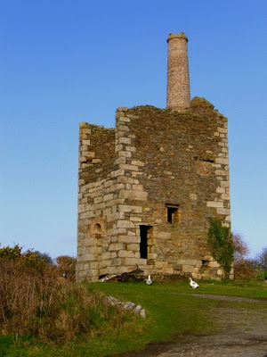
The use of stone as a modern building material is highly unusual. This is a great pity, since the local stone preserves the character of the area far better than anything else.You can find a few examples of its use, however. This wall looks as if it was built relatively recently, to replace an earlier one which has collapsed.

You can see the wall on the left of this photograph, by a gateway at the end of a row of cottages, just below where we live.

Labels:
Chapel Porth,
Coast,
Cornwall,
Flower,
Gooninnis,
Headland,
St. Agnes,
Tin Mine,
Towanroath,
Trevaunance,
View,
Walk,
Wheal Coates